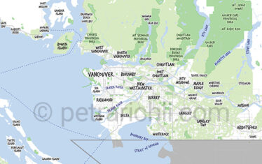
Vector Map of Vancouver and Vancouver Island
A project of love and passion for Vancouver … and meticulous vector graphics.
Now available! Vector Map of Vancouver and municipalities and Vancouver Island, British Columbia, Canada
Metro Vancouver and Vancouver Island Vector Maps
The Vancouver maps are created in Adobe Illustrator. Terrain, streets, and text are on separate layers. Text, colors and strokes can be easily changed and adapted to anything.
Do you need a customized greater Vancouver map?
Drop me a line with your wish.
For more images and vectors check out Petra Richli's stock agency portfolios
Cities on Vancouver maps
- Vancouver
- Surrey
- Burnaby
- Richmond
- North Vancouver
- West Vancouver
- Coquitlam
- New Westminster
- Township of Langley
- Delta
- Maple Ridge
- Port Coquitlam
- Port Moody
- Langley
- White Rock
- Pitt Meadows
- Bowen Island
- Anmore
- Lions Bay
- Belcarra
Cities on Vancouver Island maps
- Alert Bay
- Campbell River
- Comox
- Courtenay
- Cumberland
- Duncan
- Gabriola Island
- Gulf Islands
- Ladysmith
- Nanaimo
- Parksville
- Port Alberni
- Port Renfrew
- Port Hardy
- Quadra Island
- Qualicum Sayward
- Sidney
- Sooke
- Telegraph Cove
- Tofino
- Ucluelet
- Victoria
Recent Stock Image & Photography Portfolios
Freelance photographer located in East Vancouver
Petra Richli specializes in eCommerce product photography, animal photography and macro photography.
But she also enjoys going out and exploring greater Vancouver, BC. With the North Shore mountains, Downtown Vancouver, the hills and the ocean with the bridges… it’s easy to get a postcard image from just about any place in Vancouver. Best place to be!
#Beautiful-British-Columbia